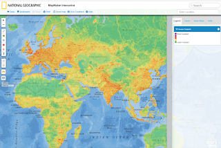
National Geographic Mapmaker Interactive
National Geographic Mapmaker Interactive is a web-based mapping tool that allows you to create and annotate maps online with lines, shapes, text, photos and videos.
Base maps include streets, satellite, and topography. You can also add included data layers such as earth systems (natural disaster hot spots, plate tectonics, surface elevation), climate and weather (climate zones, precipitation and rainfall), environment (municipal solid waste generation, superfund sites), culture (language diversity, major religions), and much more!
To view the included data layers:
(1) select the Layers tab
(2) click the Add Layer button
(3) click to select your desired layers
(4) click Done to view your map.
To view the legend/info for the map you created, select the Legend tab.
The Human Footprint map (below) shows the global human footprint, illustrating the environmental impact of human activity on Earth's ecosystems. Click on the image to see detail.


No comments:
Post a Comment